By DENNIS WYATT
209 Living
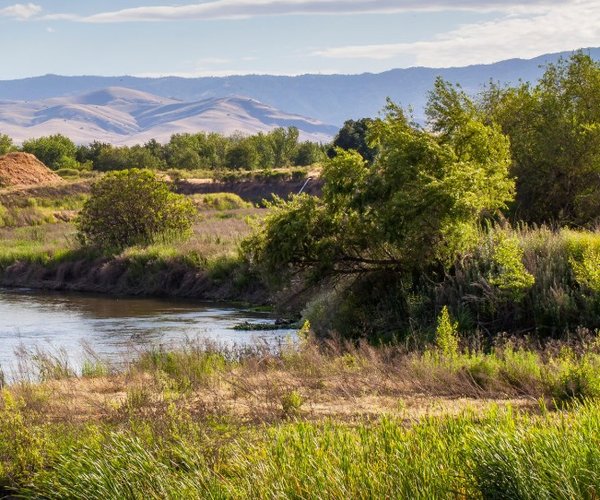
CLAYTON — Heaven is just an hour away.
It is in the form of rolling lush green hillsides, babbling streams, solitude, vast vistas, and the first signs of floral awakening from the gray days of slumbering as warmer temperatures nudge out the first colors of Mother Nature’s spring palette.
If you are in need of a workout for your heart and soul Mt. Diablo beckons.
And while its 3,849-foot summit is the highest in the Bay Area, it is what lies beneath it that lifts the spirit.
There are 90,000 acres patched together between state park, regional parks and preserves
If you want to enjoy Eden for the day it’s just an hour away.
While I’ve always like Mt. Diablo I didn’t fall in love with it until last Saturday. That’s when I took the proverbial less risk traveled by accessing the land on Eden’s east side where the Diablo Range foothills work the way down toward the Sacramento-San Joaquin Delta.
The eastern slopes offer three stunning hiking and even mountain biking areas accessed from Marsh Creek Road that is reached heading north out of Tracy on Grantline Road.
There’s the Los Vaqueros Watershed, the Round Valley Regional Preserve and the Regency Drive “gate” accessing the 20,000-acre Diablo State Park from Clayton.
The eastern side of Diablo offers a rarity in Bay Area open space given there are not only hikes for every ability and desire —whether it's part of a day that includes a leisurely picnic or a quad busting push to reach multiple summits — but it is accessed from almost pure country. Save fir Regency Drive that is part of a neighborhood on the southern edge of Clayton, there are no subdivisions in sight as you pass Mountain House and make your way thru the sleepy town of Byron. The drive in itself will help recharge your batteries as you wind along the base of the Diablo Range.
While I checked out Round Valley and Los Vaqueros my goal was a return visit to North Peak — some 300 feet lower than Mt. Diablo — and to make my first hike to Mt. Olympia at 2,964 feet.
It was my first real hike of 2018. And since I’m an admitted distance and elevation gain junkie, the hike had just what I needed to feed my addiction — a little over 10 miles and a net gain of 3,000 feet. It had the added bonus — once I veered off the trail most were taking to reach Mt. Diablo’s summit from the east so I could head to North Peak and Mt. Olympia - of having no human encounters for a good four mile stretch save one hiker who was atop Mt. Olympia when I arrived.
It sounds selfish, but nothing is grander than taking a break on a giant boulder looking out over rolling tree-studded hills wearing a late winter blanket of green with only blurry, muted signs of civilization in the distance as the rustle of a gentle breeze serenades your senses. It helped that the mercury was in the low 70s. That - coupled with sunny, blue skies - was the perfect antidote to spending much of the last four weeks in the gray embrace of a typical Northern San Joaquin Valley January.
Whether you are a Mt. Diablo State Park newbie or an old friend, this is the best time to savor the devil mountain’s heavenly offerings.
The dry winter punctured by a burst of rainfall in mid-January and higher than normal temperatures so far this month meant the first of a wave of wildflower blooms that will peter out by mid-May was barely starting on Saturday. There were just a handful if red, white, and yellow flowers budding and bursting out of their winter slumber. Near the Regency Drive gate along Donner Creek there were blankets of white daffodils obviously planted by man and not by Mother Nature.
Even if the color palate doesn’t intensify immediately, the next two weeks visiting Diablo State Park means the grass will still be a vibrant green and most trees will be at the budding stage.
Last Saturday saw plenty of young families including parents pushing strollers along former dirt roads that constituent a fair share of the trails at the state park.
The trails are abundant at Mt. Diablo State Park. And while the maps provided with the park brochure you get at entrance stations coming from the west or you download from the state park site are decent enough for the main trails that also happen to be well marked, it makes sense to invest in a more detailed map of Mt. Diablo for about $12 from REI that covers all 250 miles of trails crisscrossing the area.
One word of warning: If you opt to tackle North Peak be prepared for a steep grade near the top. The far it is semi-paved makes it worse to hike. Going up at the end is a definite quad challenger but the descent can be dicey. The reward at the top isn’t much different than Mt. Diablo in terms of what you can see to the east and much of the north. While it doesn’t have the crowds it does have a number of ambiance killing communication towers it goes with saying Mt. Olympia is my favorite of the three when it comes to solitude.
That said even if you are not into hiking take a drive to the top of Mt. Diablo in the coming weeks via the South Gate out of Danville.
The summit museum is open from 10 a.m. to 4 p.m. Bring along binoculars to take on the views from the observation deck. On a clear day — that has the best chance of happening this time of year — you can see the Farrollon Islands 27 miles west of the Golden Gate Bridge, Mt. Larsen to the north, and Yosemite Valley to the east.