An annual National Park Pass, $80.
Being a part of nature’s grandeur, priceless.
If MasterCard needs inspiration for another commercial that demonstrates the rich rewards you can reap from making a credit card transaction that can touch lives — yours included — they’d have a rough time topping the $80 you could spend on an annual America the Beautiful National Park and Federal Recreation Lands Pass.
There are more than 2,000 locations across the United States it can be used.
The pass covers entrance fees as well as day use fees for a driver and all passengers in a vehicle in a vehicle area. It also covers up to four adults for sites that charge admission per person.
And there is no other state with as many national parks you can use the pass at than in California.
Not only are there 10 national parks – two more than runner-up Alaska – but the national parks in the Golden State have the most variety. They include unique desert ecological systems and glacier carved Sierra valleys to soaring redwoods and a volcano that last erupted 104 years ago.
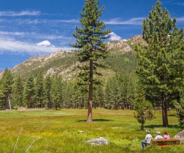
Two of those national parks — Yosemite and Pinnacles — are easy day trips from our area of the Valley.
Each park has a $35 entrance fee that’s good for seven days. That means just two trips to Yosemite and one to Pinnacles within the 12 months after you purchase a pass saves you money.
An even bigger bargain is the $80 lifetime pass for those 62 years and older.
The passes are available for purchase at entry points to national parks or online via the National Park Service.
The farthest drive to a national park in California is Death Valley; about a seven-hour drive. The only one you can’t drive to per se is the Channel Islands National Park. It is 29 miles offshore from Santa Barbara by plane or boat.
Here’s a rundown of what California’s 10 national parks have to offer.
Yosemite
There is a reason as many as 4 million people from all parts of the globe make their way to the only national park in the 209.
It offers everything from stunning glacier carved valleys surrounding by soaring granite, alpine lakes, towering 14,000-foot peaks, incredible waterfalls especially between late March and early May, and more than 750 miles of hiking trails within its 1,069 square miles.
The good thing — and the bad thing — is more than 90 percent of visitors spend all their time within the seven square miles of the 3,000 to 3,500 foot deep Yosemite Valley. That means you’ve got 1,062 square miles of splendor with much of it just you and nature.
Lassen
California has more active volcanoes — as defined by the United States Geological Survey — than any state in the 48 lower states. There are eight with Mt. Shasta soaring to 14,179 feet being the most visible.
But there is only one that inspired a national park — Mt. Lassen.
Not only did it last erupt in 1917 but it is also the world’s largest dome volcano. It was that eruption that prompted the preservation of the devastated area for future observation and study as a national park.
The 10,412-foot peak rises above a wide array of volcanic features such as Bumpass Hell, the largest geothermal feature in the park, and the Sulfur Works. There are more than 140 miles of hiking trails.
The park is popular in winter for cross country skiers, backcountry skiers, and snowshoeing enthusiasts given Mt. Lassen can often get more than a 25-foot deep of snowpack in winter.
The park is in northeast California between Redding and Susanville.
Redwoods
The Redwoods National Park complex also involves state parks.
This is where you will find the tallest living things on earth — soaring redwood trees.
Among them is Hyperion. At 379.1 feet it is the world’s tallest living tree. Good luck finding it as the location is a closely guarded secret.
No worries. There are plenty of other soaring giants to inspire you. The unique ecological system makes walking among the giants an experience you will never forget.
Redwoods once dominated the rugged Northern California coast from as far south as the Santa Cruz mountains to the Oregon border.
The trees, which can live to be thousands of years old, have been 96 percent logged. You will find just over half of the remaining redwoods within the national and state parks.
Located in extreme northwest California the trip there is a visual treat of rugged coastline and large patches of pristine wilderness.
Kings Canyon
Many people group Kings Canyon with Sequoia when they think of national parks. They are even managed by the same national park unit.
Kings Canyon is arguably the bigger gem given limited access by car.
It features a large unspoiled swath of the central Sierra. It’s jammed with seemingly endless lakes, deep glaciated canyons, and waterfalls. There are more than 20 peaks over 13,000 feet.
The park’s 462,000 acres are a backpacker’s paradise although the trails are good for in and out day hiking.
It also protects the striking headwaters of the middle fork of the Kings River and the south fork of the San Joaquin River that are considered by many to be the most pristine and picturesque river segments on the western slope of the Sierra.
The main attractions that can be reached by car are both worth the trip. They are Grant Grove — a collection of giant sequoias — and Kings Canyon itself. Its name was inspired by its steep sides.
Sequoia
Like Kings Canyon, Sequoia National Park is accessible by heading east out of Visalia.
It’s named for its marquee attraction for those that access the national park by vehicle. The giant sequoias are the biggest trees in earth by volume.
You will find plenty of the sequoias that grow on the western slopes of the Sierra between 5,000 and 7,000 feet.
The biggest portion of the national park is above the tree line with stunning granite peaks and plenty of lakes and canyons.
The most popular destination for those on foot is the 14,505-foot high Mt. Whitney — the tallest peak in the contiguous United States that is in the border of Sequoia National Park and Inyo National Forest.
The vast majority head in for a long day hike or a two-day hike. You can backpack in from the west by traversing much of Sequoia National Park.
Pinnacles
Pinnacles is California’s newest national park having been conferred that status in 2013. It was declared a national monument in 1908 to protect the remnants of a volcano created 23 million years ago during an eruption on California’s most famous earthquakes fault zone — the San Andreas Fault.
It is a collection of volcanic created features mellowed over the passage of time in the form of cliffs, talc caves, spires, smooth boulders and jagged ridges.
It is located south of Hollister — earthquake city USA — in central California.
Point Reyes
Point Reyes National Seashore is north of San Francisco along the Marin County coast.
It features secluded bays with sandy beaches, meadows home to wild tule elk, rare plant life, and vistas for whale watching.
The scenic seashores along the jagged point of California that juts out into the Pacific Ocean was created by the tectonic plates along the San Andreas Fault moving in opposite direction over the course of millions of years.
Death Valley
How surreal is Death Valley?
A part of it was used to film the first Star Wars movie.
It was apropos given the landscape, stark terrain, weather, abundance of wildflowers, birds, and other species as well as much of it being literally isolation in plain sight makes Death Valley seem galaxies away from other national parks including those in desert settings.
It is where you will find the lowest point in the Western Hemisphere at 266 feet below sea level and within 14 miles you can be at the highest point in the national park, Telescope Peak at 11,049 feet.
The world’s highest reliably measured air temperature was recorded at Furnace Creek on Aug, 15, 2020 when it reached 130 degrees. Ground temperatures on the valley floor in spots can be in excess of 200 degrees in the summer. Yet snow can fall there and sometimes in significant amounts such as in the 1930s when several feet piled up at the northern end of the valley.
Annual rainfall is less than 2 inches but it is not usual every year or so for concentrated rain to hit in such a manner on a landscape unable to absorb moisture rapidly through the Gironde or via plants that walls of water run down canyons undercutting rock, wearing down stone and then flowing into areas where manmade items such as restrooms on a concrete slab near Zabriskie Point are moved 30 yards.
And if you’re a stargazer, it is tough to top what you can see in the nighttime sky from the valley floor anywhere else in California thanks to imposing virtually barren mountains blocking out manmade light on the horizon.
Joshua Tree
The preservation of Joshua trees would be enough to create a national park that includes the high Mojave Desert and the lowlands of the Colorado Desert.
There’s hiking and rock climbing for those inclined.
But the appeal that lures many to Joshua Tree National Park is the peace and quiet along with incredible sunsets and the fanciful visual forms the park’s namesake trees and geology creates for gazers and photographers alike.
Channel Islands
The five islands that make up what many call “America’s Galapagos” is the Channel Islands National Park.
It requires a 29-mile trip by air or water to reach from Santa Barbara given it is surrounded by the Pacific Ocean.
There are 2,000 plus species of animals and plants. Of those, 150 you will find nowhere else on the planet.
Whales and dolphins pass by on a regular basis.
Autumn is popular for scuba divers and kayakers.
Visitors rate the sunsets as some of the most specular they’ve ever seen on the ocean vista.