
Want to get high in the 209?
If so, the question is how do you want to do it?
Is your preferred option driving, taking an elevator, hiking, or jumping out of a perfectly good airplane?
Let’s start with the least amount of physical exertion.
That would be hopping in your car, turning on to Highway 120 and driving east for a few hours until you reach Tioga Pass at 9,943 feet on Highway 120.
The eastern entrance station that sits at the pass is in the middle of the highest highway pavement in California.
The section of roadway through Yosemite National Park is Tioga Road. It is Highway 120 when it passes the Big Oak Flat or Tioga entrances to the park.
The highest road in California is Rock Creek Road that ends at 10,239 feet in the Inyo National Forest. The terminus is at the trailhead at Mosquito Flat.
There are higher unmaintained roads that are almost always gated off or even treacherous for four-wheel drive vehicles that can be found in the White Mountains.
The highest among those is the one that leads to the summit of “the” White Mountain at 14,252 feet.
But that is digressing.
Both Rock Creek Road and White Mountain are in Inyo County and not the 209.
The window is rapidly closing to drive to Tioga Pass as it closes down for the season after the first significant snowfall.
That said, you can put it on your to do list for late spring in 2026 as the scenery from a car window is impressive as are roadside attractions on the way such as Tioga Lake and Tuolumne Meadows, both that are easy to explore on foot.
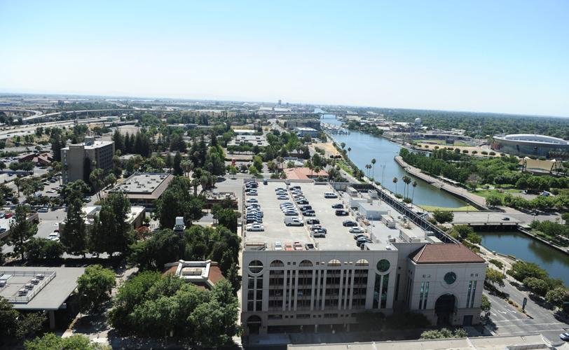
The tallest point in the
209 reached by elevator
If duty calls, you can ascend the highest building in the 209.
No, it is not the 16-story Doubletree Hotel in Modesto where you need to book a room to take in the views from the upper floor that tops out at 195 feet.
Besides, the views aren’t as impressive as from the tallest building — the 13-story San Joaquin County Courthouse at 286.1 feet in Stockton.
The juror waiting area is a spacious space on the 13th floor facing the west with a bank of large windows complete with an outdoor balcony area.
It offers views of the Diablo Range, the Stockton Waterfront, and part of the Delta.
It is light years away from the old courthouse where potential jurors descended into a cramped, drab, and windowless basement to await the cattle call for a courtroom.
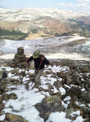
The highest place you
can hike to in the 209
The tallest point you can hike to in the 209 is on the eastern border of Yosemite National Park.
It is Mt. Lyell at 13,114 feet.
While Mt. Lyell takes a two-day trek to conquer from the trailhead and requires some mountaineering skills, you can easily hike Mt. Dana, some 63 feet shorter.
At 13,051 feet, it is the second highest point in the 209 and is a seven-mile “walk up” from Highway 120 when Tioga Pass is open. It is by far the easiest to access 13,000-foot plus peak in the state.
While it is too late in the season to try it this year, you might want to tackle it after Memorial Day.
The strenuous half-day hike covering 5.8 miles starts just west of the park’s eastern entrance at Tioga Pass on Highway 120.
It includes striking views of Dana Plateau with its sheer drop-offs as well as Mono Basin.
From the summit of Mt. Dana you get a sweeping view of the Sierra’s spine including the largest glacier in Yosemite.
It is not a maintained trail but it has been so well traveled, even above the tree line, that it is breeze to follow.
It is worth dedicating the hours in the dead of winter to stay in shape so you can make your way to the roof of the 209.
I plan to make a return trip — I’ve hiked to the summit five times over the years — next summer.
It is best to peak and start back down by early afternoon as thunderstorms are a common occurrence in the late afternoons along the Sierra crest even when they are not in the forecast.
I’ve passed generous patches of snow on the way up, another time I summited to see the end of a wedding ceremony, and once covered the last quarter mile after the mountainside had been pelted with hail in early August.
The best part is you can make it there and back as a one-day excursion.
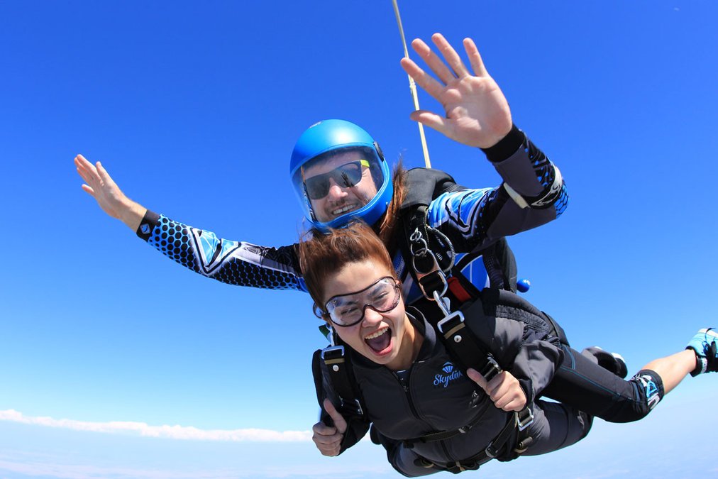
Taking a plane to jump
out of above the 209
The best sky-high views of the 209, I’ve been told, can be found eight miles southwest of Manteca.
It involves jumping out of a Skydive California plane from a private landing strip on Kasson Road in Tracy.
Skydive California offers an opportunity to get a glimpse of the 209 from 10,000, 13,000, and 15,000 feet with corresponding free falls of 30, 60 and 75 plus seconds.
It’s time for a disclaimer.
I’ve been close to 15,000 feet above sea level but it was with my feet planted on terra firma atop Mt. Whitney at 14,464 feet.
The reason I mention that is back in 2015 a week before I made my third ascent of the highest ground you can stand on in the continental United States, I charged a tandem jump on my credit card.
It was a bit father north at the Skydive Lodi Parachute Center along Highway 99.
It was a birthday gift for Sawyer, a former boyfriend of my oldest granddaughter.
I opted out of going up myself as I figured with my luck I’d sprain my ankle on landing somehow — even though I’m told that is rare — and have to cancel the hike I had been looking forward to for nine months.
I’d be lying, though, if I didn’t admit the last time I had a sizable amount of air under my feet for a sustained period it was over the Pacific Ocean off of Maui.
It was only 15 minutes and right around 300 feet high at the end of a line pulled by a boat, but the fact I lost my grip with one hand just before the boat started a wide turn, I ended up experiencing a “thrill” that I swore I never wanted to repeat.
How bad was it? Outside of 10 stern words punctured with a swear word I said when I was asked “gee, wasn’t that fun” after I got reeled back into the boat, I didn’t utter another word for 40 minutes until we were maybe 100 feet from the dock in Lahaina.
I bring this up not to scare anyone off especially since I’ve been in precarious places hiking that literally terrified a nephew I had brought along, but to point out there are those among us who have an aversion to jumping out of a perfectly good airplane.
That said, I have one acquaintance that has sky dived over a hundred times.
Clearly, I can’t speak about an actual personal experience plummeting down to earth strapped to the front of an experienced sky diver at either the Kasson Road skydiving center or its Lodi counterpart.
And yes, the cost at Lodi is a bit less.
But the fact you have three tandem jump options and it’s taking place above familiar territory are big selling points for Skydive California.
It is eight miles as the drone flies from Yosemite Avenue and Main Street in downtown Manteca to Skydive California. It is a 10-minute drive via the 120 Bypass and Interstate 5 or a leisurely 15-minute drive going the backway via Airport Way.
They operate Friday through Sunday year-round.
Tandem sky dive options include:
*$199 for a 10,000-foot dive with 30 seconds of freefall that’s offered on Fridays only.
*$249 for starting at 13,000 feet with 60 seconds of freefall.
*$299 for starting at 15,000 feet with 75 seconds plus of freefall.
You need to be 18 years of age and not weigh more than 225 pounds. Booking in advance is the way to go although there is an outside chance you can get same-day reservations if they have capacity by calling 209-835-7474.
Other than that, there is a wealth of information at their website, skydivecalifornia.com
To contact Dennis Wyatt, email dwyatt@mantecabulletin.com